The Cookham Plan
Findings and Recommendations
Environment and Land Group
5. TOURISM
| MAIN REPORT INDEX | ENVIRONMENT AND LAND INDEX |
5.1 Tourism in the Cookhams:
The Cookhams have a number of attractive qualities and facilities that encourage a large number of visitors. This has advantages for the local economy, but also has some disadvantages, such as increasing traffic and parking congestion.
Cookham Village is architecturally attractive and sited next to a beautiful stretch of the Thames Valley, and is easily reached from West London. The Stanley Spencer Gallery and the connection between the village and Spencer’s work mean Cookham is a well
known place name throughout Britain and indeed abroad.
The quality of the landscape and the built environment is recognised by the number of listed buildings and extent of conservation areas, and also by the many areas of open land owned by the National Trust, to preserve their character.
Many additional visitors arrive in Cookham due to the Chartered Institute of Marketing at Moor Hall, and the Odney Club, owned by John Lewis Partnership. As training and conference centres, these bring in delegates and trainees who are also able to explore the
local area.
The Cookhams are well endowed with pubs and restaurants, some with histories of several centuries as licensed premises, with capacity well beyond anything the Cookhams could support without the number of visitors.
The riverside location includes overnight moorings which are seasonally very popular, and the river effectively provides another gateway to the village and its facilities. The Thames landscape and riverside walks are also a major draw for visitors from outside
the area arriving by car, coach and train.
Proximity to Cliveden and the attractive riverside town of Marlow are also likely to bring in visitors making a whole day-out in the area. Data on these connections to other local tourist attractions should be collected and analysed to build a clearer picture.
5.2 Issues/problems:
The Stanley Spencer gallery generates a number of coach party visits throughout the year, but there is no parking or waiting area for them in the Village. Coaches have to drop off near the busy corner of Sutton Road and High Street and then ‘hover’ near the war memorial parking bays, or presumably drive further away and return to collect their passengers. Visits often also include Holy Trinity Church and the riverside area.
Car parking is limited, and can be visually intrusive, ironically damaging the appearance of the very landscape people have come to visit. Parking encroaches onto meadow grass areas of the Moor at busy weekends, despite grassed mounds being built up along the roadside verges a few years ago. The National Trust car park quickly fills up serving walkers heading to the river and visitors heading for the pubs and restaurants in High Street. Plans for a larger car park behind the hedgerow are well documented elsewhere. The scheme was defeated due to the level of local objections through the planning process. The small car park in Sutton Road is too small to have a useful turnover of spaces.
The volume of car parking needed is only likely to increase. Arrival by train, bicycle, on foot and by river should be encouraged. Once the visitor has arrived in the Cookhams, by whatever means, local information is no always readily available. The idea of providing some sort of tourist information centre is suggested. This could be in the form of a small retail outlet, or possibly a mobile unit that could be positioned in busy areas at busy times. Guides and leaflets should be published and made available in local hotels, at CIM, Odney Club, Library, railway station, and in suitable dispensers near the riverside moorings.
5.3 Walking in the Cookhams:
The Cookhams (Cookham Village, Cookham Rise and Cookham Dean) benefit from a network of public footpaths linking the village areas to wonderful surrounding countryside and the neighbouring towns of Marlow and Maidenhead as shown in http://www.rbwm.gov.uk/public/070514_prow_CookhamParishMap_636kb.pdf .
The Thames Valley here includes some unspoilt scenery, with a wide floodplain in places, and steeply sloping sides in other, where geology and erosion have combined to form the more dramatic scenery of Cliveden Deep and Winter Hill.
Three longer distance paths pass through the Cookhams including the Beeches Way (16 miles West Drayton to Cookham), The Green Way (5 miles Bray to Cookham) and The Thames Path National Trail (184 miles).
These longer distance routes connect Cookham to a wider area, and of course short sections of these routes can be walked and combined with other paths.
There are advantages in circular routes that begin and end in the same place, and routes that include plenty of points of interest and refreshment stops, of which there are plenty in the area.
Linear routes are also possible, especially by using the Maidenhead to Marlow railway branch line.
In the Cookhams there are areas of common land, riverside landscape and open space owned by the National Trust, and just outside the Parish boundaries are the Cliveden Estate to the East, and Quarry Wood, owned by the Woodland Trust, to the West.
There are historical and cultural links around the Cookhams, most famously with the painter Sir Stanley Spencer, and author Kenneth Graham.
Because the Cookhams are quite spread out, there are various suitable starting points for walks in the area. Cookham Station is centrally placed in Cookham Rise, and also has a car park. Cookham Dean common has a small parking area off Winter Hill Road, and
there is limited parking in Cookham Village and on Cookham Moor.
Walking the Parish boundary, or beating the bounds would once have been an annual event, before the days of accurate Ordnance Survey mapping. Usually boundary marker stones were set at points around the legal boundary and the walk would link these.
There are not public rights of way for whole boundary, but with permitted paths and a few adaptations it makes an interesting circular walk.
East Berkshire Ramblers Association has published a number of carefully planned walks in the Cookham area, generally between 31/2 and 7 miles in length, in their Rambling for Pleasure series.
5.4 Developments and proposals:
5.4.1 New Footpaths
Despite the large number of footpaths in the area, some useful connections are missing, such as a link from Sutton Road to the Thames in the south of the Parish, near Widbrook Common, which we understand is in the RBWM plan.
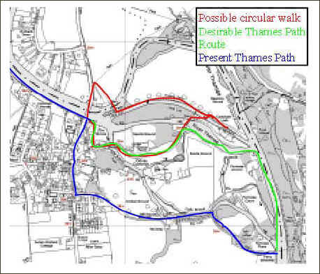
Figure 2 © Crown Copyright 2007
In the long term we would like to see the Thames Path routed alongside the rivers throughout the Parish as shown in green on Figure 2, but as this is private land it is unlikely to proceed without cooperation of the owners. The Steering Committee decided
not to pursue this.
5.4.2 Waymarked Routes
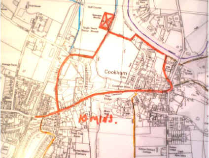
Figure 3 © Crown Copyright 2007
A number of waymarked routes could also be developed, of various lengths and with different themes, such as a Stanley Spencer Trail, or routes visiting a number of wildlife sites. These could be identified by different coloured waymarking discs and posts, and
linked to a locally available walk and trail guide. These could be developed by Cookham Parish Council working closely with East Berks Ramblers Association. An example is shown as Figure 3. It is understood that the National Trust is interested in piloting a Geographical Positioning System (GPS) linked to mobile phones in the Cookham Area. We would strongly support this, as items of interest as well as directions could be transmitted, ideally suiting this principle of waymarked routes.
5.4.3 The Pound
Investigate ways of making The Pound more pedestrian friendly and/or provide a viable alternative footpath route between Cookham Rise and the Moor. The questionnaire showed that 82% of respondents that answered the question were in favour of investigating a path behind the Pound. This is discussed in the main plan document and in Traffic and Transport proposals.
5.4.4 Saches Island
This is now under control of The Environment Agency, but the River Oxbow is still marked private and there are obstacles in the river. However we would like to see FP65 continued over the weir, as shown in Figure 4.
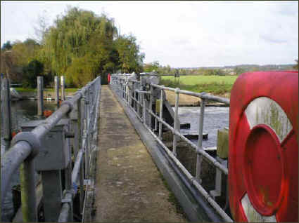
Figure 4
There are precedents for this at Hurley. It would enable another very attractive circular route, if a route across a small area of land on the Buckinghamshire bank can be negotiated. This is shown on Figure 2. Consideration was given to trying to open up Saches Island, but The Steering Committee felt that this should be left as a wild life area.
5.4.5 Old Sewage Works
Thames Water Property Services have admitted ownership of this site, and their position is that no remediation will take place without funding, possibly from some other development in the Borough.
However the group feels that this site is dangerous, as fences have been broken and there are no longer any danger signs. There are no signs of ownership and no emergency phone numbers. We feel that Thames Water should show some responsibility for remediation of this site.
The area could become attractive to walkers as many footpaths pass nearby and picnic tables and footpath maps could be provided, to provide a mini information centre. The access road could form part of the cycle route discussed in Section 5.7.
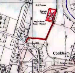
Figure 5 © Crown Copyright 2007
5.4.6 Other Areas
Footpaths away from the river are less well used, and signposting of routes and maps could encourage more use of footpaths around Cookham Dean and Quarry Wood.
Admittedly the footpaths themselves are well signed, but without numbers.
5.5 Publicity
Publicity of the footpaths, sites of interest, viewpoints, Conservation Areas, Green Belt, etc. together with refreshment facilities and virtually non existent toilet facilities are poor for the arriving tourist and for local residents.
The only way of obtaining information on Conservation Areas is by obtaining a booklet from the Town Hall at a cost of £5. We believe that this information should be readily available in leaflet or booklet form, with the most important information areas as
illustrated in the appendix.
Detailed maps at 1 to 10000 scale should be mounted on display panels around the village, showing
• ‘You are here’,
• waymarked routes,
• footpaths
• sites of interest.
An example of a suitable map is mounted at the station; unfortunately it refers the observer to Maidenhead Library for further information. This highlights the problem!
5.5.1 Leaflet Proposals
At present only The Ramblers map of local footpaths is available in a limited way. We believe that a series of leaflets, with the same style as the street signs, should be produced, with possible examples below. All should show Points of Interest, Viewpoints, Conservation areas, refreshment facilities, etc. as appropriate:-
• Waymarked paths,
• Cookham Village Footpaths,
• Cookham Dean Footpaths,
• Footpaths from Station
• Cycle Routes
• Bridle Paths
• Cookham Countryside brochure showing places of interest, see an example from another village in Figure 6
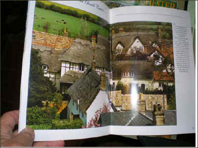
Figure 6
5.5.2 Information Distribution Centres
Provision of information, brings the need for a method of distribution, and of course no self respecting town or village is without a Tourist Information Centre (TIC) these days.
Respondents to the questionnaire point out the danger of attracting more tourists to the area, but this is inevitable with the refurbishment of the Stanley Spencer Gallery. If information is only available locally, it should be helpful, particularly if the centres are located in the three villages in existing outlets such as Cookham Dean PO, Station Parade, Spencer Gallery. These will help spread the load around the Cookhams, and could be established quickly, whilst awaiting permanent facilities as recommended in
the Business and Economy Report. A mobile centre could be useful initially. A new use for the Old Cobblers shop is perhaps possible.
5.5.3 Importance of Station Parade
At present the majority of tourists concentrate on the village. We believe it is important to spread the load and develop this area as a TIC, travel point, and with extra parking facilities. Waymarked routes from here could be developed as shown in Figure 5.
However a key requirement here is the need for improved pedestrian access through or round the Pound. This issue is discussed further by other groups.
 5.6
Village Entry Signs
5.6
Village Entry Signs
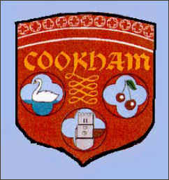
Such signs have recently been placed at the entrance to Maidenhead and Windsor, and were placed at the main entrances to Cookham, during Twinning in the 1980s.
These need replacing. The use of the Cookham shield, previously used is shown as Figure 7 .
They could be enhanced by gate like features at the side of the road, further defining the boundaries of the Village. We recognise the need to strike a balance between good signage and an overload of street furniture.
Figure 7
5.7 Cycle Route
5.7.1 Cycle paths.
Some numbered routes have been identified by SUSTRANS and are identified by standard blue and white signs. The Green Way provides a cycle route away from traffic from Lightlands Lane in Cookham to Northern Maidenhead, but still deposits the cyclist
on busy roads at both ends. The combined cycle/footpath alongside the Switchback Road ends at the junction with Maidenhead Road, south of the railway bridge, so again the cyclist is back on busy roads before reaching Cookham Rise or Cookham Village.
 5.7.2
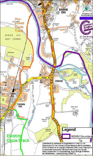
Extend Cycle Track to Bourne End
5.7.2
Extend Cycle Track to Bourne End
Investigate ways of extending cycle paths so there are off-road routes for the whole distance of useful – as well as interesting and attractive - cycle journeys. To be developed in conjunction with RBWM, Parish Council and SUSTRANS. One route favoured by respondents of the questionnaire is to complete the link from the Greenway to Bourne End with an unobtrusive route as shown in
Figure 8. This should help separate cyclists from the pedestrians on the very busy Thames Path by the river and provide a link with the existing cycle route, without using The Pound. It would also further justify removal of the sewage works previously mentioned.
There are many references to the difficult exit from the Greenway in Lightlands Lane in the questionnaire.
Figure 8