The Cookham Plan
Findings and Recommendations
Housing and Development Group
3. TOWN PLANNING
| MAIN REPORT INDEX | HOUSING AND DEVELOPMENT INDEX |
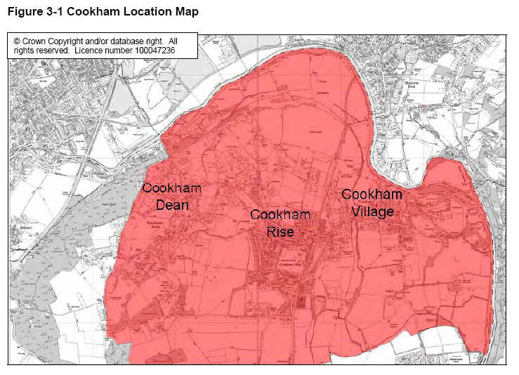
click on map for larger image
The red shaded area shows the overall extent of Cookham (based upon the Parish Council boundary). Note that the area extends slightly to the south of the map where the southern boundary runs along Malders Lane, Hindhay Lane and along the northern boundary of Furze Platt.
The approximate centres of the three settlements of Cookham Dean, Cookham Rise and Cookham Village are highlighted.
3.3.1 Cookham Dean
Cookham Dean (the ‘Dean’) is a rural area within which a number of distinct settlements can be identified. These include: the main village area around St John the Baptist Church, the School and Post Office; Cookham Dean Bottom; and Winter Hill. There is a primary school, a nursery, 4 pubs/restaurants, a post office, 2 village halls and a number of
commercial enterprises. The buildings are all in Green Belt with many also in Conservation Area and/or in an Area of Special Landscape Importance. (See Figure 3-6, Figure 3-7 and Figure 3-8). According to the Cookham Dean Conservation Area Statement (3.3), the Cookham Dean of today grew from a 14th century settlement most likely
centred on Cookham Dean Bottom. This grew with the establishment of farmsteads in the surrounding area but most of the buildings seen today date from the early 19th century onwards.
The area is distinctive for its hilly nature, the liberal sprinkling of common land (the result of Cookham’s notable success in resisting enclosure) and its network of small lanes and footpaths which connect the various parts of the village
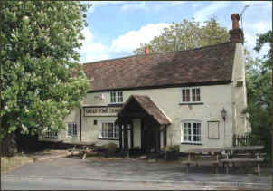
Figure 3-2 Uncle Tom's Cabin, Cookham Dean (Mike West)
.
Development in Cookham Dean is generally of a low density with many large, detached houses set in their own grounds. These are interspersed with smaller cottage style properties and a smaller number of modern style houses.
The majority of properties are constructed of traditional materials, notably brick, flint and clay roof tiles although a number are of older timber framed and / or thatched roof construction.
3.3.2 Cookham Rise
In the middle of Cookham is Cookham Rise (the ‘Rise’) which is the largest and most densely populated of the three main settlements. It is built around the railway station on the Maidenhead-Marlow branch line with connections to London and Reading. Cookham Rise is mostly surrounded by Green Belt but has no other significant planning protection. The area contains most of Cookham’s main facilities including a primary school, a nursery school, the library and parish
council office, medical centre, dentist, day centre and a variety of shops and restaurants, many serving the villagers day to day needs. There are also two churches, a village hall, scout hut and sub-Post Office. Most of these facilities are located around the station and along Lower Road.
The public facilities, shops and business premises are generally small scale buildings of traditional appearance and materials although the parade, nursery and primary schools are in a more modern style. The shop units are home to a wide variety of retailers and provide a very important local facility (particularly with growing awareness of the importance of shopping locally and reducing car use). They and the other local businesses play a vital role in defining Cookham as a thriving and living community rather than as just another dormitory village.
Unfortunately, a number of the shop units, notably Countrystore and the Parade are of an unattractive modern design made worse by some poor maintenance of both buildings and the surrounding landscaping.
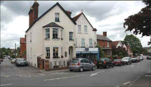
Figure 3-3 Cookham Rise (Mike West)
Much of the housing stock dates from the 19th and 20th centuries and includes a wide range of styles and sizes. Along Lower Road and High Road in particular are many terraced cottages originally built for farm workers. Alongside these and in areas such as Westwood Green and Whiteladyes Lane there is more of a mix of semi-detached and detached properties in a variety of styles but mainly with gardens and mature planting which creates a pleasant suburban environment. The roads around Whiteladyes Lane include many former council houses built in the 1950s and 60s which are now in either private or housing association ownership. This stock also includes some low rise flats and maisonettes. To the south east of the Rise is Strande Park, a small estate of mobile homes which provides an important source of lower cost housing for Cookham.
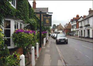
3.3.3 Cookham Village
Cookham Village (the ‘Village’) is the oldest part of the area, having grown up around the ancient river crossing and parish church. The Village is surrounded by Green Belt, has an extensive Conservation Area and is further protected to the north and east by land designated as being important to the setting of the Thames (see Figure 3-6, Figure 3-7, Figure 3-8 and Figure 3-9) Much of the area of the Village is also deemed to be at risk of flooding (see Figure 7-6 and Section 7).
The Village is mainly residential in nature except for the High Street area which has a mix of residential and commercial buildings (approximately: 52% residential, 37% Retail/residential and 11% commercial). The commercial/retail buildings consist of restaurants, clothes shops, 3 garages, 2 florists, 2 hairdressers, a travel agent and several other specialised shop outlets catering in the main for visitors to the village. In addition, there is the Stanley Spencer Gallery, a primary school, the main parish church, two residential care homes and a fire station.
The Village also hosts two of the largest local businesses – the Chartered Institute of Marketing at Moor Hall and the John Lewis Partnership’s training facilities and social club at the Odney. (John Lewis also own Winter Hill Golf Course).
The majority of the properties in the Village are in the Cookham High Street Conservation Area which extends from the Odney Club in the east to Poundfield in the west (see Figure 3-7).
According to the Conservation Area Statement(3.1), the main boundaries of the Village have developed from the medieval settlement and have not changed significantly since at least 1761. This is reflected in there being 50 listed buildings within the Cookham High Street Conservation Area, three of which are grade 2* and the rest being grade 2 listed.
Figure 3-4 Cookham Village (Mike West)
The character and appearance of the Village depends heavily on the use of a limited range of traditional material and building styles and features, mainly brick, flint and clay tiles with some older timber framed buildings. The more modern buildings are generally of traditional construction with brick and slate or tiled roofs. The largest concentrations of modern housing date from the 1950s onwards and can be found in Sutton Close, Woodmoor End and Vicarage Close although there are other examples. Most properties are detached or semi detached (apart from in the High Street) and most houses are of a medium to large size.
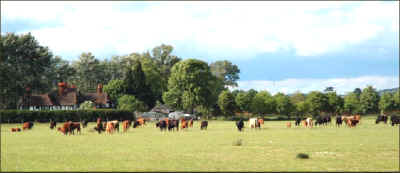
3.3.4 Farmland, Commons and Open spaces
Just as important as the built environment is Cookham’s rural setting amid farmland and open spaces. These spaces are considered in more detail in the Environment and Land Working Group’s report but the main features (as they relate to the setting of the village and to potential future development) are described below.
In the Cookhams the majority of the farmland is situated to the south of Cookham Village, south and west of Cookham Rise and south and east of Cookham Dean. Nearly all of this land is in the Green Belt and it serves the purpose of separating the villages from Maidenhead whilst also adding green space between the different parts of Cookham, so
maintaining the distinctiveness of each centre. To the north lies the important open spaces of Marsh Meadow, Cock Marsh and Winter Hill. In this area, , apart from Winter Hill Golf Club, the land is predominately agricultural. It is classified as Green Belt, of Special Landscape Importance and important to the Setting of the Thames.
Historically, Cookham was very successful in resisting the enclosure of common land and so enjoys the benefit of many sites within and around the settlements. The National Trust owns Cookham Moor, Cock Marsh, Widbrook Common, Winter Hill, Cookham Dean Common, Bigfrith Common and a few other smaller areas in and around Cookham Dean
whilst the Parish Council administers Odney Common in Cookham Village. Details of registered Common Land can be found on the Natural England web site (3.3).
Figure 3-5 Farmland, Cookham Village (Mike West)
The National Trust’s ownership at Cookham falls within a raft of protective planning policies, including Green Belt, Conservation Area and land Important to the setting of the River Thames. Following consultation during preparation of the Cookham Plan, the Trust has confirmed its support for continued protection of the quality of the open countryside
around Cookham and stated that it would like to see a continuation of the principles established by the RBWM Core Strategy, namely to protect such landscapes and their setting, to protect and enhance historic environments and to promote appropriate levels of development only within the existing urban fabric.
Other significant open Spaces include: Riverside and Bell Rope Meadow (between Holy Trinity Church and the river), Poundfield, Westwood Green and the Alfred Major Recreational Ground all of which play an important part in defining the Rise and Village’s open and semi-rural environment. Bell Rope Meadow, Westwood Green and and the Alfred Major Recreational Ground are classified as Important Urban Open Space. Poundfield has been the site of a number of planning battles over a potential housing development and was formerly classified as Green Belt. Following a legal challenge, this status was removed from much of the site in 2001 (the High Street Conservation Area was extended to cover much of Poundfield at this time).