|
Paris
Guest
|
The metal bridge over Strande water, at the back of CIM has been blocked by black wrapped bales of silage. So no-one can walk, ride, cycle or whatever across the stream at that point.
It's been in use as a bridleway and footpath for as long as I can remember (over 40 years) so who ordered this to be done and how can we get it cleared?

|
|
|
|
|
|
Roger
|
 |
« Reply #1 on: July 20, 2019, 11:43:00 AM » |
|
It does look a if someone really does want it blocked rather than just dumping rubbish.
|
|
|
|
|
|
Cookham Webmaster
|
|
« Reply #2 on: July 20, 2019, 12:09:49 PM » |
|
Put the photo on the internet in flickr or whatever. Then use the icon on this page just below the I and insert the URL. Alternatively type in "[ img]http://URL.......[/img ]" Do not put in the spaces that I have done by the img it is because it does not show up on the post otherwise.
|
|
|
|
|
|
Cookham Webmaster
|
|
« Reply #3 on: July 21, 2019, 12:48:44 PM » |
|
This is one of the photos 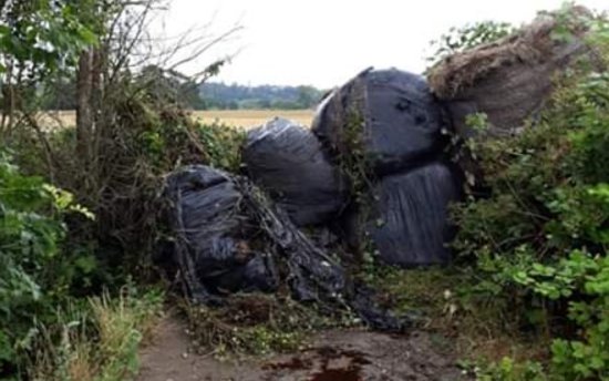 |
|
|
|
|
|
James Hatch
|
|
« Reply #4 on: July 21, 2019, 05:40:15 PM » |
|
That bridge was originally built by the Astor's so they had access to their fields on the west side of Strande Water and only used by farm traffic and it was closed by a locked gate. Then in the 1950's the farm manager removed the gate for the ease of tractor traffic. My wonder is, has the fields on the west side of Strande Water been sold on the QT! It would be worth investigating. Mind you they are all in flood known area. After the gate was removed of course it soon became a walkers right of way, and it joined up with a well established footpath from Cookham to Maidenhead.
|
|
|
|
|
|
CLIPPER
|
|
« Reply #5 on: July 22, 2019, 07:11:09 AM » |
|
Speaking to other well established Cookham Residents, they also confirm what you have echoed here James, for as long as they can remember, they have had access to cross the fields as short cuts. One resident even recalls visiting stand Castle and having 'cream teas' at the folly. This weekend has been a pain, I could not walk / cycle through, along with a number of other walkers who were in disbelief that someone could just do this 'over night'. The person who has blocked this path this side of Cookham and on the other side of Sutton Road, really is not in the keeping of the 'spirit' of Cookham, no notice given either. If its who I think it is, then as Cookham Residents had mentioned to me, it is just expected. Lets hope the Fresh, Newly Elected Cllrs can do something about  |
|
|
|
|
Ian64
Newbie

Posts: 28
|
|
« Reply #6 on: July 22, 2019, 08:04:45 AM » |
|
Lets hope the Fresh, Newly Elected Cllrs can do something about
I'm one of the old stale cllrs but I'm still happy to investigate this on your behalf!
|
|
|
|
|
Kate
Administrator
Jr. Member
Posts: 66
|
|
« Reply #7 on: July 22, 2019, 11:55:52 AM » |
|
Keep an eye on the RBWM Landowner Declaration register: https://www3.rbwm.gov.uk/info/200215/rights_of_way/893/landowner_declaration_register"The Growth and Infrastructure Act 2013 requires the council to keep a register of landowner statements and declarations lodged under Highways Act 1980 and landowner statements lodged under the Commons Act 2006. Highway Act statements and declarations enable landowners to formally acknowledge public rights of way across their land and, in doing so, create a presumption that they have no intention to dedicate any further routes across their land. Commons Act statements allow a landowner to deposit a landowner statement accompanied by a map which brings to an end any period of recreational use 'as of right' over the land to which the statement and map relate." You may find useful information on the Open Spaces Society website: https://www.oss.org.uk/. Have a look here: https://www.oss.org.uk/what-do-we-fight-for/footpaths-rights-of-way/claiming-a-public-footpath/Having previously completed a village green application myself (in a different county) I can confirm this sort of thing is not for the faint-hearted, but with local evidence, good research and attention to detail it is certainly achievable. |
|
|
|
|
TaylorMadeLiveries
Newbie
Posts: 27
|
|
« Reply #8 on: July 22, 2019, 01:30:34 PM » |
|
Hi Kate
Yes that is correct you can fill out a declaration of all public rights of way across your land thus creating a legal interruption for the purposes of a '20 year new footpath claim'.
|
|
|
|
|
TaylorMadeLiveries
Newbie
Posts: 27
|
|
« Reply #9 on: July 22, 2019, 01:31:24 PM » |
|
Howeveeerrrrr.....if there is a 20 year period that predates that legal interruption a new footpath can still be created. In the case of the above path the evidence is pretty good.
During your searches if you come across a legal interruption it could be mine, filed about 6 years ago. Its because we have many permitted footpaths across the land and I want horses to have priority on our created paths.
Mark
Not sure why it made me write that in 2 posts...phone maybe
|
|
|
|
|
Kate
Administrator
Jr. Member
Posts: 66
|
|
« Reply #10 on: July 22, 2019, 02:06:56 PM » |
|
Thanks Mark. As it currently stands it would seem the landowner in this case is perfectly entitled to protect his land unless the 'right of way' appears on the definitive map; if it does then the obstruction should be reported to RBWM rights of way, if it doesn't then the good people of Cookham have a defined legal process to complete to have the route added should they so wish. What is important to note for those who are concerned about the loss of historic walking routes in Cookham is that there are legal changes proposed with the intention of drawing a line in the sand in 2026, such that any routes which are not recorded on the definitive map by that date may be automatically extinguished. Again from the OSS website: "under Part II of the Countryside and Rights of Way Act 2000, historical footpaths and bridleways, which came into existence before 1949 but which have not been recorded on the definitive map and statement by 1 January 2026, may be extinguished (the precise criteria for extinguishment have not yet been set out in regulations). " So if you (collectively, not just Mark!) plan to challenge this instance it may be worth forming a Cookham working party to examine the definitive map and ensure all the rest of your well-loved and well-used historic paths are on it and challenged if not. It's not legally a 'right of way' if it's not on the definitive map. The relevant definitive maps are online at RBWM here: https://www3.rbwm.gov.uk/info/200215/rights_of_way/1017/definitive_map_of_public_rights_of_way |
|
|
|
|
|
Cookham Webmaster
|
|
« Reply #11 on: July 22, 2019, 02:57:05 PM » |
|
I would have thought the Ramblers Association would have been on to it too. I wonder what happened to the Cookham Society?
|
|
|
|
|
Kate
Administrator
Jr. Member
Posts: 66
|
|
« Reply #12 on: July 22, 2019, 08:34:01 PM » |
|
I appreciate the disappointment, I felt exactly the same when our local open space was under threat and we had to dedicate a huge amount of time and effort to address the situation. Unfortunately emotion and narrative are not going to fix the problem, there is a defined legal framework for challenging your issue and only facts and due process will work; the landowner recognises this and has quite reasonably put the wheels in motion to protect his asset for his business/employees/family. It is going to take willingness, teamwork, community spirit and hard slog to get there. It's really up to all of the Cookham community whether they feel this is a cause worth pursuing.
I've done pretty much all I can to give you the information you need to make a legal challenge, the rest is up to all of you responding to this post on this forum. If you really feel strongly that this is an issue which should be addressed in the interests of the wider Cookham community then garner support from all the local bodies that you can and spread the workload. Good luck, and hopefully your combined efforts will give you the outcome you seek.
|
|
|
|
|
|
CLIPPER
|
|
« Reply #13 on: July 23, 2019, 11:51:50 AM » |
|
Sadly - we are again having to fight for 'our' Corners of Cookham. If this ''person'' gets away with this, they will be coming back for those previous 'applications' with the intent to change the face of Cookham forever !
|
|
|
|
|
Cookham Society
Jr. Member
Posts: 78
|
|
« Reply #14 on: July 23, 2019, 11:56:49 AM » |
|
Lots of our members have reported that access has recently been blocked on a very popular footpath between Cookham Moor and Strand Water. The Cookham Society is very concerned about this and intend to identify who is responsible, why it was done and how it can be resolved legally. At this point we can advise that it is a 'track' and not a 'right of way'. It joins footpaths 49 and 50 and forms a beautiful circular walk allowing easy access to Strand Water from the Moor Car Park for residents and visitors. As far as we know it has been in constant use for over 50 years without hindrance which makes its sudden closure without any apparent reason seem rather spiteful and unnecessary. Unfortunately resolving a dispute like this is likely to take a long time - and a big tractor! We will keep you updated on any developments. 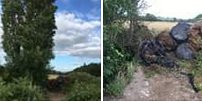 |
|
|
|
|
|