The Cookham Plan
Findings and Recommendations
Housing and Development Group
3. TOWN PLANNING
| MAIN REPORT INDEX | HOUSING AND DEVELOPMENT INDEX |
3.4 Protecting Cookham’s character and surroundings
At present, Cookham’s environment enjoys a relatively high degree of protection through a combination of policies covering:
-
Green Belt
-
Conservation Areas
-
Special Landscape Importance
-
Open Spaces
-
Land important to the Setting of the Thames
-
Flood Plain
-
Other special designations such as Sites of Special Scientific Interest (SSSIs) and Wildlife Heritage Sites.
-
Normal planning principles supplemented by specific local policies
Although the special designations provide enhanced protection for Cookham, this is not absolute. Continued pressure, both from developers wishing to exploit the strong local demand for property and also from the government struggling to provide sufficient housing for the buoyant south east economy are likely to remain a fact of life for the foreseeable future.
This ambiguity is reflected in comments made during preparation of the plan when, on the one hand, many wished to see more affordable housing and homes for their families in Cookham, whilst, on the other hand, there was an overwhelming desire expressed to maintain the size and character of the village.
In the following sections, we consider the protection given by each aspect of the planning rules and consider some of the good and bad points. Planning law is a complex area and, whilst we attempt to summarise the key factors affectin
Cookham in this report, it must not be taken as a definitive guide to policy or its implementation.
Local planning rules are made up from a combination of the law, government guidelines and local policy (see Appendix 2). The government requires local planning authorities to comply with national policy as set out in relevant legislation, Planning Policy Guidance Notes and Statements (PPGs / PPSs). At a regional level, policy is set out in the Regional Spatial Strategy (RSS) which covers matters such as housing, transport, the environment, the economy, infrastructure and mineral extraction( 3.4). Local Policy is set out by RBWM in the Local Development Plan, this comprises:
-
Royal Borough of Windsor and Maidenhead Local Plan (incorporating alterations adopted in June 2003)( 3.4) together with:
-
The Berkshire Structure Plan 2001-2016 (2005); the Replacement Minerals Local Plan for Berkshire (Incorporating Alterations adopted in 1997 and 2001) and the Waste Local Plan for Berkshire (1998)
The Borough has recently embarked upon a consultation exercise to replace this plan with a new Local Development Framework (LDF). This comprises a Core Strategy together with a number of supporting policies (including a regional spatial strategy) which will be developed over the coming years. It is vital that due account is taken of the Cookham Plan and its associated working group reports in developing these policies.
Significant policies in the existing Local Plan and draft Core Strategies are listed in Appendix 2.
At the centre of the LDF will be the Core Strategy and Policies Development Plan Document (the ‘Core Strategy’). This document was issued for consultation in late 2006 and a independent inspector will review the representations made during June 2007.
It is unfortunate that the consultation on this document took place prior to completion of the Cookham Plan which means that the issues raised in this report could not be formally submitted to RBWM. The Cookham Society has, however, made representations that Parish Plans should be taken into account in developing the LDF and it is to be hoped that the inspector will support this view.
Throughout this report, we have referred to the draft policies in this document wherever possible (these are prefixed ‘CS’). Where necessary for clarity or detail, we have also referred to policies from the existing Adopted Plan, these
have various prefixes (e.g. GB).
3.6 Planning Principles and local policies
The consent of RBWM as Local Planning Authority is required before anyone develops land or buildings (unless the alterations are very minor in nature).
‘Development’ includes:
-
changing the use of land and/or buildings
-
construction or alteration of building
-
most other construction and engineering works
Permission is granted in accordance with relevant law, government planning policy guidance and local policies. There are a number of specific policies addressed to commercial developments in Cookham, these are highlighted in section 11 (Commercial Development).
3.6.1 Green Belt
The purpose of the Green Belt is set out by the government in Planning Policy Guidance note 2 (PPG2) and is:
1) To check the unrestricted sprawl of large built up areas
2) To prevent neighbouring towns from merging into one another
3) To assist in safeguarding the countryside from encroachment
4) To preserve the setting and special character of historic towns
5) To assist in urban regeneration, by encouraging the recycling of
derelict and other urban land
RBWM apply this guidance through the adopted local plan, particularly policies GB1 to GB10 ( to be superseded by Policy CS2 in the new Core Strategy). The overwhelming thrust of these policies is that development will only be allowed in the Green Belt in limited ‘special circumstances’ which meet the criteria laid down in the policies.
Draft Policy CS2 states that:
Within the Green Belt, development will only be granted, save (sic) in very special circumstances, for:
1) The construction of new buildings for:
a) Agriculture and forestry
b) Essential facilities for outdoor sport and recreation, for cemeteries and any other uses of land that preserve the openness of the Green Belt and which do not conflict with the purposes of including land in it
c) Limited extension, alteration or replacement of existing dwellings
d) Limited residential infilling in Recognised Settlements
e) Limited affordable housing in accordance with CS19
f) Limited infilling in or redeveloped (sic) of identified major existing developed sites
2) The re-use of buildings and the making of material changes in the use of land which maintain openness and do not conflict with the purposes of including land in the Green Belt
3) Engineering and other operations which maintain openness and do not conflict with the purposes of including land in the Green Belt.
All development either within, or conspicuous from, the Green Belt should not cause harm to its visual amenities and where appropriate enhance the appearance of the countryside.
Changes to the Green Belt will only be made in exceptional circumstances.
Figure 3-6 Green Belt within Cookham
click on map for larger image
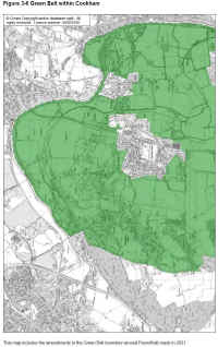
In principle, this provides a very high degree of protection to the land around Cookham Village and Cookham Rise and to all of Cookham Dean. However, the wording is slightly less restrictive than the existing policies coupled with which recent years have seen a number of developments which do not obviously meet the specified criteria. These include new facilities at Moor Hall and some residential developments on Winter Hill.
Given that this report does not support large scale development in and around Cookham, it seems appropriate the principles of Green Belt Policy should remain unchanged and that settlement boundaries should be defined for the Village and Rise to remove any ambiguity about infilling opportunities. It would also appear that residents concerned about development in the Green Belt should (individually or through the Cookham Society) ensure that there is clear accountability from RBWM for decisions made.
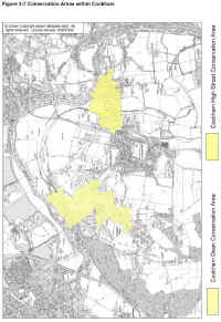
Figure 3-7 Conservation Areas within Cookham
click on map for larger image
Conservation Areas are established to provide a commitment to preserve and to enhance the special character or appearance of an area. These areas are protected by the Planning (Listed Buildings and Conservation Areas) Act 1990 and earlier legislation.
The protection regime recognises that the special character of these areas does not come from the quality of their buildings alone. The historic layout of roads, paths and boundaries; characteristic building and paving materials; a particular 'mix' of building uses; public and private spaces, such as gardens, parks and greens; trees and street furniture, which contribute to particular views - all these and more are important.
Conservation areas give broader protection than the listing of individual buildings: all the features, listed or otherwise, within the area, are recognised as part of its character.
Within a conservation area the local authority has extra controls over:
-
demolition
-
minor developments
-
the protection of trees
Some of the means by which local authorities can enhance the
appearance of conservation areas are:
-
preparing special development briefs for sites they identify as detracting from the character or appearance of the area;
-
ensuring that new buildings harmonize with or complement their neighbours in scale, style and use of materials;
-
making environmental improvements, for example by reinstating historic paving materials, sympathetic landscaping and planting, or removing unsightly elements such as hoardings;
-
integrating road signs and markings as far as possible with the character of the street;
-
controlling the position and design of advertisements and shop signs;
-
ensuring that traffic safety and control measures harmonize with the landscape.
Within the Royal Borough’s Adopted Local Plan, development in Conservation Areas is guided by Policies CA1 to CA6 (to be superseded by CS12 in the Core Strategy). The existing policies provide for:
-
Applications for new buildings to be submitted with full details of
Applications for demolition are to be accompanied by details of the replacement development scheme and will where appropriate,
RBWM to:
1. Require that any development will enhance or preserve the
2. Require the retention of any building and the protection of views that contribute to the distinctive character of the Conservation Area
3. Require proposals for new buildings and extensions or alterations to existing buildings to be of a high design standard and sympathetic in terms of siting, proportion, scale, height, form, materials and detailing to adjacent buildings and the character of the area in general
4. Not permit the use of inappropriate synthetic materials and require the use of traditional materials for windows, doors, shop fronts, canopies, fascias and rainwater goods
5. Require changes of use to be sympathetic to the character of both the building and the overall Conservation Area and not to lead to an undesirable intensification of activities in the area
6. Not grant permissions on sites which form important open spaces within the conservation area or sites which by their openness form part of the essential character of the conservation area
7. Require the retention of all significant walls, fences and hedges.
Conservation Areas are also provided with additional protection to their character under Policies: CA3 (original architectural features), CA4 (environmental improvements and management of conservation areas), CA5 (street furniture) and CA6 (car parking in conservation areas).
Owners of property in a Conservation Area, should comply with the normal planning controls which affect everyone else but additionally extra controls also apply – for example, written authority is required for the following (this is not a definitive listing):
-
Demolishing buildings larger than 115 cubic metres in volume. This can include some garden walls.
-
Making additions and alterations to the roof of a house (including dormers)
-
Cladding the outside of a house with stone, timber, tiles or any synthetic/ imitation material
-
Installing satellite dishes on the front of the building
-
Cutting down, lopping or topping most trees
The regulations for house extensions, garden building and advertisements are also different in Conservation Areas.
As can be seen, there is less emphasis on preventing development in Conservation Areas than on ensuring that development is appropriate to the local character and that opportunities are taken to enhance the appearance of the area. New Policy CS12 is mush less prescriptive than the existing arrangements and it is to be hoped that the promised
supporting policies will provide more detailed protection consistent with the existing policies.
During preparation of the Cookham Plan, no strong case was identified to change the boundaries of the existing Conservation Areas (although we would not object if other working groups wished to bring forward cases based on traffic and parking issues or nature conservation / environmental grounds).
We have identified a number of sites within the Cookham High Street Conservation Area where past developments do not appear to have complied with the spirit of the policies and where there is a case for a special development brief to be prepared in readiness for any future development. These sites could include: Barnside, Church Farm Autos and The Forge garages; The Peking Inn; The Fire Station and restaurant sites – particularly where these generate traffic and parking problems, noise and strong smells which detract from the nature of the Conservation Area.
3.6.3 Areas of Special Landscape Importance
The objective of this designation is to ‘protect and enhance valued landscapes, preserve and enhance existing wildlife habitats and provide opportunities to create new areas of nature conservation interest, in both rural and urban areas’. It is also intended to ‘maintain and enhance the level of tree and hedgerow cover within the Borough and to promote
opportunities for environmental education within the Borough and to ensure that new development maintains and enhances the quality of the natural environment’ Policy N1 states that:
Within the areas of Special Landscape Importance as shown on the proposals maps (see Figure 3-8), land uses and development which would detract from the special qualities of that landscape will not be permitted. The Borough Council will in particular resist proposals that would:
-
Adversely affect both long distance and local views within these areas;
Figure 3-8 Areas of Special Landscape Importance within Cookham

*The Steering Committee decided not to pursue these proposals. Enquiries about this Map should be made the Planning Department of the Borough Council.
-
Result in the loss of tree cover and hedgerows or adversely affect the
ecological
value of the area;
-
Adversely affect formal landscape features and their settings.
Where development is permitted, special care will be taken to ensure its siting, scale, height, design and materials respect the surrounding landscape. extensive landscaping of any new development will also be required.
The currently designated areas focus on undeveloped chalk hill land and we consider that this designation should be extended to much of the land around Cookham in order to provide enhanced protection for the important views from the village as well as those from further afield (see Figure 3-8). In particular, it should be extended to include:
-
All Green Belt land within Cookham to the east of the Railway (there may be a case for the southern boundary to extend to the full extent of the Green Belt in this area). This would enhance the protection of the important landscapes around Widbrook, Strand Water and White Place Farm. (Refer to the report of the Environment and Land Working Group which additionally considers nature conservation issues in these areas).
-
All Green Belt land within Cookham to the west of the railway and to the north of Long Lane (again, there may be a case for extending the area to include all Green Belt in this area to protect the views from Cliveden and from North Maidenhead.
Policy N1 will be superseded by the very general Policy CS7 in the Core Strategy. It is vital that the promised detailed supporting policies maintain similar levels of protection to those existing at present.
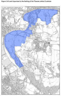
3.6.4 Land Important to the Setting of the Thames
The stretch of the Thames which forms Cookham’s northern and eastern boundaries is recognised as being one of the most picturesque sections of this world famous river. The importance of protecting the setting of the river is recognised in RBWM’s Policy N2 which states:
The Borough Council will conserve and enhance the setting of the Thames, as defined on the proposals maps (see Figure 3-9) and will not permit development which would adversely affect the character and setting of the river in both urban and rural locations. Proposed development will be required to meet the following criteria:
-
the character, height, scale and bulk of the development respects the
the protection of important views of and from the river;
the retention of existing waterside buildings where these are
the retention of tree-cover and the conservation of the ecological
existing public access should be retained and, in appropriate
We consider that this important protection should be retained and strictly enforced. Unfortunately, Policy CS8 in the draft Core Strategy is less prescriptive than N2 and will require detailed supporting policies in order to have a similar effect.
Figure 3-9 Land important to the Setting of the Thames within Cookham
(click on map for larger image)
3.6.5 Flood Plain
Flood risks to Cookham are considered in more detail in Section 7 of this report. The problem is recognised by RBWM in Policy F1. This provides that:
Within the area liable to flood as shown on the proposals maps, or within other areas subject to flooding, development will not be permitted for new residential or non-residential development, including extensions in excess of 30 square metres, unless it can be demonstrated to the satisfaction of the Borough Council, that the proposal would not of itself, or cumulatively in conjunction with other development:
-
impede the flow of floodwater; or
-
reduce the capacity of the flood plain to store flood water; or
-
increase the number of people or properties at risk from flooding.
Notwithstanding this policy, there have been a number of large scale developments within the Flood Plain in recent years. These include extensions to the Chartered Institute of Marketing and the new conference facility at the Odney Club.
Until such time as Cookham has the benefit of a comprehensive and effective flood relief scheme, we consider that this policy should remain unchanged and should be strictly enforced.
At the time of writing, the extent of land classified by RBWM as being in the Flood Plain is not published. Supplementary guidance on the interpretation of Policy F1 was adopted by RBWM on 27 May 2004 based on revised flood risk maps issued by the Environment Agency following completion of the Maidenhead, Windsor & Eton Flood Alleviation Scheme ( 3.7). Following investigations into the flooding in 2003, the status of these maps changed and the Borough withdrew the maps from the guidance document. At the time of writing, it is understood that the areas subject to Policy F1 are broadly as shown in Figure 7-6.
The new Policy CS10 in the Core Strategy provides a more risk based approach assessing development proposals.
3.6.6 Rural Communities
All of Cookham is designated as a ‘Rural Community’ and so is covered by Policy CS3 which states that rural communities will be sustained by:
-
Requiring any new development to be of a scale and form which
Ensuring new development is designed to be safe and accessible to
Supporting initiatives which preserve the range of rural community
Ensuring new development is concentrated in or near local service
Identifying opportunities for affordable housing to meet local needs
Facilitating appropriate diversification of the rural economy
Supporting rural transport initiatives
Protecting the best and most versatile agricultural land from
3.6.7 Other Restrictions
In the previous sections, we have considered the main planning policies which affect the size, structure and shape of Cookham. In addition to these, there is a wide range of ancillary policies covering matters such as Tree Preservation Orders, Sites of Special Scientific Interest (SSSIs) and Wildlife Heritage Sites which are applicable to Cookham.
The impact and importance of these measures is considered in more detail in the Environment and Land Working Group’s report but we recognise and endorse their continued importance to maintaining the special characteristics of Cookham.