The Cookham Plan
Findings and Recommendations
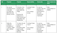
Housing and Development Group
3. TOWN PLANNING
| MAIN REPORT INDEX | HOUSING AND DEVELOPMENT INDEX |
3.7 Adjacent Planning Authorities
Our review of planning within Cookham has focussed on those policies which are directly applicable in the area of the Village – i.e. those set by RBWM. We must remember that Cookham is bounded on two sides by other authorities and
that, with the Thames forming the boundary between districts, our neighbours in Wycombe and South Bucks have a strong role in shaping our surroundings.
Wycombe District Council sets planning policy for the north bank of the Thames from west of Cookham along to Hedsor Water (just upstream from its confluence with Cookham Lock Cut). Policy is set out in the council’s adopted plan( 3.9) and the land designations are similar to those used by RBWM. In particular:
-
All apart from Bourne End and Riversdale is classified as Green Belt.
-
Abbotsbrook and Riversdale are designated as Conservation Areas.
-
Virtually all of the river bank and the land for some distance behind it is classified as Flood Plain.
-
Much of the river bank south of the Marlow Branch Line and the fields north of Sashes Island are classed as an Area of Attractive Landscape.
-
The grounds of Hedsor Park are classified as Parks and Gardens of Historic Interest.
This would generally appear to provide a good level of protection and should be retained and enforced. The exceptional areas are the sewage works south of Little Marlow which is classed as a ‘Major Developed Site within the Green Belt’
and so is potentially able to be developed (albeit on a similar scale) under Policy GB9 and the hotel site to the east of the Marlow by-pass, any expansion of which should be subject to the normal Green Belt and Flood Plain restrictions.
South Bucks District covers the eastern boundary of Cookham from Hedsor Water to Maidenhead and, as would be expected, has applied strong protective measures to the eastern banks of Cliveden Reach. Their Local Plan( 3.10)
classifies the land between the river and the crest of the hill as:
-
Area of Attractive Landscape
-
Green Belt
-
River Thames Setting
-
Historic Park and Gardens.
From Cookham’s point of view, this is most welcome and should be continued and strongly enforced.
3.8 Planning Process and Enforcement
As we have described above, Cookham’s special character is generally well protected by existing planning policies but there have been a number of issues raised in our consultation which give concern about how effective their coverage
and enforcement is. These include:
-
Housing developments within the Green Belt on Winter Hill.
-
Extensive alterations and extensions to the Chartered Institute of Marketing’s premises at Moor Hall in the Green Belt and Flood Plain.
-
Construction of a large conference centre at the Odney Club within the Conservation Area, Setting of the Thames and Flood Plain.
-
Extension to Charlescote House in the High Street in the Conservation Area and the area covered by Policies CKM1 and CKM4.
These examples show that local people cannot rely on existing policies to prevent development in protected areas. This can only be done where there is good visibility of applications and where local people and organisations such as
the Cookham Society challenge proposals and hold officers accountable for decisions made and councillors accountable for providing and managing a suitable level of planning officers. Coupled with this is a need for rapid and effective enforcement action when work is undertaken without permission or not in accordance with what was approved.
Another major planning issue raised during consultation involves increases in the density of development (including the loss of gardens to infill development and the redevelopment of sites such as the former Colin Hatch yard to higher densities) which existing policies seem unable to prevent despite local residents’ concerns. There seems to be a strong case for additional measures such as designating garden areas as ‘Important Urban Open Space’ or an ability to justify lower densities than those set by government policy where local conditions dictate. It is to be hoped that pressure can be brought to bear on these matters through development of the LDF and a Village Design Statement (see below).
The protection that Conservation Areas receive vary from council to council. In a large part it will depend on the size of the workforce and funding of the local department. RBWM offer the following services for conservation:
-
maintaining records of listed buildings, conservation areas, register of Historic Parks and Gardens and sites scheduled as Ancient Monuments;
-
providing specialist advice on listed buildings and buildings in conservation areas;
-
production of Conservation Area Appraisals;
-
leaflets with further details in regard to listed buildings, conservation areas and the grant scheme are available from the Conservation team.
Enforcing conservation requirements relies on the planning and planning enforcement officers keeping a watchful eye on developments or the public informing the department of changes or alterations in the area. With 27 conservation areas in the borough much of the reporting must come from the public.
3.9 Village Design Statement and Local Planning Guidance
As stated above, we strongly hope that the matters covered by the Cookham Plan in general and this report in particular will influence RBWM in finalising and implementing the new Local Design Framework.
There is provision within the LDF for Village Design Statements (VDSs) to be formally adopted as supplementary planning guidance provided that they are based on widespread consultation and are suitably formatted. The preparation of a VDS is beyond the scope of the Cookham Plan but we strongly recommend that steps are taken to build on our work by creating a VDS for Cookham which is consistent with the Cookham Plan and ensuring that it is adopted by the Borough Council.
3.10 Key Findings
Our key findings from the review of Town Planning related matters are set out below. These are based on a combination of our reviews of planning policies and the common themes which emerged from the consultation process and questionnaire.
-
Cookham is special because of its semi-rural setting, mixture of building types and uses. This is what makes it attractive to most residents and it is important that this balance should be maintained.
-
Cookham does not have the space to support any significant level of development. This means that it is not possible to meet people’s aspirations for more affordable homes other than through small scale developments. See Appendix 4 for an illustration of this point.
-
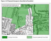
Green Belt Policy is vital and should be supported. There should be no reduction in the areas classified as Green Belt and the *Poundfield site should be returned to Green Belt in the new Local Development Framework (see Figure 3-10). This proposal excludes the field next to the Nursery School which may be suitable for appropriate development for community related schemes.
-
To support enforcement of Green Belt Policy, *the boundaries of Cookham Village and Cookham Rise should be defined as the edge of the Green Belt.
-
There is a belief that better visibility and enforcement of planning applications and decisions is needed. This needs more rapid and proactive communication between RBWM and local people and better coordination and consultation between locals and groups such as the Cookham Society and Parish Council.
-
The RBWM should take the findings of the Cookham Plan and its supporting working group reports into account in finalising the Local Development Framework and updating the Proposals Map and other supporting documents.
-
Careful attention should be paid to the development of the LDF and its supporting policies. The impression from the current draft is that the core policies are generally less prescriptive than the current Local Plan and it is vital for Cookham that this should be addressed and there is no weakening of the current protection which we enjoy. Full and active consultation with local people must be undertaken during the development of the LDF.
-
A Village Design Statement should be produced as a matter of urgency. The format and timing of this should be agreed with RBWM to facilitate its early adoption as Supplementary Planning Guidance.
-
In conjunction with preparation of the Village Design Statement and in consultation with RBWM, Design statements should be developed for the Conservation Area Sites for CA sites listed in section 3.6.2.
-
Areas of Special Landscape Importance should be extended as shown in Figure 3-8 to cover (at least):
a. All Green Belt land to the east of the Maidenhead to Cookham railway line (to support the setting of the Area of Attractive Landscape on the east bank of the Thames and the undeveloped flood plain land south of Cookham).
b. All Green Belt land west of the Maidenhead to Cookham railway line and north of Long Lane (including Poundfield (to protect the setting of Cookham Dean and the view of the ridgeline from Maidenhead and Cookham Rise).
-
It is important to monitor any changes to and enforcement of planning policy in Wycombe District and South Bucks District.
Figure 3-10 *Proposed Changes to Green Belt at Poundfield
click on map for large image
3.11 Action Plan
click on chart for larger image