The Cookham Plan
Findings and Recommendations
Housing and Development Group
7. FLOODING
| MAIN REPORT INDEX | HOUSING AND DEVELOPMENT INDEX |
7 FLOODING
7.1 Remit
Consider flood risks to Cookham and how these affect housing and development matters.
7.2 History of Flooding
7.2.1 Flood Events
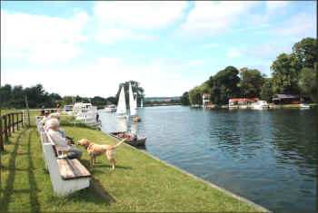
Cookham has a long relationship with the Thames. The village’s origins are closely linked with its ancient role as a crossing place and today the riverside scenery and walks are an important part of the village’s attraction and an amenity which draws in many visitors.
Figure 7-1 The Thames at Cookham (Mike West)
Unfortunately, the river is not just a benign presence and, over the years, Cookham has suffered from flooding on a number of occasions. Whilst the Thames poses the obvious and major threat to the village, other types of flooding such as flash flooding and drainage problems have also caused problems in recent years. Major Thames floods have included
those in :
• 2003 • 2000
• 1990 • 1974
• 1947 • 1894
In addition to these events, flash flooding occurred in Cookham Dean and Cookham Rise in 1989 and localised flooding of the High Street has occurred on numerous occasions following heavy rain. Isolated flooding caused by local problems such as blocked drainage gullies or sewer pipes is also a regular source of inconvenience.
Out of 644 responses to the questionnaire, 136 people (21%) considered that their homes could be at risk from some form of flooding. Of those who considered themselves to be at risk, the source of their concerns were:
River Thames 47%
Flash Flooding 27%
Drainage Problems 19%
Other sources 7%
The approximate locations of those expressing concern is shown in The impact of flooding Flooding of homes and businesses has a devastating effect and can lead to significant emotional and financial trauma. Fortunately there has not been any significant internal damage to properties in Cookham since the 1989 flash floods although a number of homes in the Lightlands Lane area suffered limited damage in 2003.
Apart from damage to property, businesses and personal effects, flooding in Cookham brings the risk of damage to farmland, crops and livestock and disruption to roads and public transport. During significant Thames floods, all roads into Cookham Village can become impassable (apart from the single track Causeway) and bus and rail services are also
subject to disruption.
Figure 7-2. As can be seen, concern about flooding from the Thames is concentrated around the main flood plain areas in the Village and the Rise together with properties at the foot of Winter Hill. Flash flooding concerns are surprisingly widely distributed but generally appear to focus on the more steeply sloping areas around Cookham Dean and Winter
Hill. There is probably some overlap between concerns about flash flooding and drainage problems since but we were surprised by the extent that this was a worry to people.
7.2.2 The impact of flooding
Flooding of homes and businesses has a devastating effect and can lead to significant emotional and financial trauma. Fortunately there has not been any significant internal damage to properties in Cookham since the
1989 flash floods although a number of homes in the Lightlands Lane area suffered limited damage in 2003.
Apart from damage to property, businesses and personal effects, flooding in Cookham brings the risk of damage to farmland, crops and livestock and disruption to roads and public transport. During significant Thames floods, all roads into Cookham Village can become impassable (apart from the single track Causeway) and bus and rail services are also subject to disruption.
Figure 7-2 Flooding Concerns
Click on chart for larger image
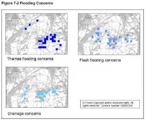
The maps show the approximate locations of respondents who expressed concerns for each category of risk based on analysis of their post codes (where provided).
When the Causeway is in use, access to the Village is made more difficult by pedestrians sharing this route with traffic and by the presence of sightseers. This can lead to severe congestion and a significant risk of emergency vehicles not being able to reach the village not to mention the risk of accidents to pedestrians.
The flash floods were caused by thunderstorms which led to high run-off from the fields around Cookham Dean. This was channelled down the dry valley through Cookham Dean Bottom and Lower Road leading to a number of properties being flooded, mainly in the Lower Road and Grange Road areas. In addition, the exceptional rainfall and its drainage through the gravel and chalk strata led to the subsidence of several properties in the High Road area at least one of which was demolished and rebuilt as a consequence.
In addition to physical damage, the threat of flooding has an economic impact by affecting the value and saleability of property and placing restrictions and additional costs on development proposals.
7.3 Flood Alleviation Measures
In recent years, there has been considerable investment in flood alleviation measures in Cookham.
7.3.1 Flood Drains
Following flash floods in the late 1980s, RBWM spent a considerable amount installing a flood drain along Dean Lane and Lower Road. This has its outfall in the Fleet ditch on Cookham Moor. Further up the valley several bunded balancing ponds were created to hold back the flow in the event of a repeat event.
Fortunately, there has not yet been a repeat of the flash floods. There is no data to indicate whether this is due to the success of the relief scheme or the absence of a similar downpour but, for now, given that this matter was not raised as a significant concern during consultation for the Village Plan, it seems reasonable to assume that the risk has been significantly reduced.
Several respondents to the questionnaire reported that high levels of runoff posed a risk in several roads around Cookham Dean and Winter Hill and we recommend that RBWM carry out detailed studies to identify the risk and what could be done to alleviate it.
7.3.2 Improved Drainage to the High Street
In 2006, RBWM identified the cause of this problem to be the collapse of the highway drain outfall at the western end of the High Street. Work was undertaken to replace this but unfortunately, to date, problems persist after heavy rain. This should be remedied by RBWM as part of normal highway maintenance and does not require action under the
Cookham Plan.
7.3.3 Maidenhead Windsor and Eton Flood Alleviation Scheme (MWEFAS)
MWEFAS was a £100m plus project to prevent a repeat of the 1947 flooding of Maidenhead, Windsor and Eton. So far as Cookham is concerned, its main components were:
-
The Jubilee River which runs from Boulters Lock to Black Potts Railway Viaduct below Windsor.
-
A flood bund on the northern edge of Maidenhead together with an associated weir to control flood flow into Maidenhead Ditch.
-
Flood bunding around the western and northern edges of Cookham Village (this and the Maidenhead bund can be seen marked in red dashes in Figure 7-6.
MWEFAS opened in June 2002 amid great expectations that it would solve flooding problems across the area. Unfortunately, these were proved wrong only 7 months later during the January 2003 flood. The scheme has attracted much controversy over its failure to meet its design capacity and its impact on the flooding of areas above and below Maidenhead. As far as the Cookham Plan is concerned, there are three key issues:
-
The scheme was not intended to reduce flooding around Cookham. Such flooding is caused by capacity limitations through the weirs and channels around Cookham Lock and these limitations were not addressed by the scheme.
-
The bunding north of Maidenhead and a consequent reduction in flow through the Maidenhead Ditch raises flood levels in Cookham. Modelling carried out for the Environment Agency ( 7.1) suggested that the increase was 140mm in Strande Lane and 330mm on Widbrook Common in January 2003.
-
Concerns which have been raised about the extent and effectiveness of the bunding around the village.
Flooding from the Thames represents the most serious risk to the low lying areas of the village and to understand these matters and their potential solutions better, we need to look at how flooding takes place in Cookham.
Figure 7-3 Cookham Bund January 2003 (Roger Davies)
7.4 How the Thames Floods
Flooding at Cookham is caused when the flow in the river exceeds the capacity of the channel and the structures within and around it. Once the river has burst its banks, the flood and its effects progress through a number of stages until the flow subsides.
7.4.1 Water Flow
The factors which lead to flood conditions are very complex and were outlined in the Mechanisms of Flooding Report ( 7.2) and the Review of Recent Flooding in the Thames Valley report ( 7.3). In essence, the risk factors are:
-
Heavy rain
-
Saturation of the catchment area leading to quicker run-off in to the Thames and its tributaries
-
Snow or ice melting and producing increased flows.
The 2003 flood involved the first two of these factors whilst the more damaging 1947 flood also involved snow and ice melting.
7.4.2 Capacity Limits
Prior to the river overflowing, capacity at Cookham is determined by the sluice gates on the Cookham and Odney Weirs and by flow through the Lulle Brook. The weir gates are managed by the Environment Agency and are normally fully opened at times of flood risk. Once their capacity is exceeded and the river has overflowed, secondary factors come into play as the level progressively increases, these include the capacity of the culverts under the B4447 across the Moor and under Lower Cookham Road at Widbrook Common. In an extreme event, the capacity of the arches supporting the Causeway bridge would become the critical factor and if this was exceeded or impaired (e.g. by debris), significant property damage would become likely.
7.4.3 Progressive effects of flooding
Once capacity of the weirs is exceeded, the river usually first bursts its western bank in the northern part of Marsh Meadow, this leads progressively to:
-
Flooding of Marsh Meadow and increased run-off into the Fleet Ditch.
-
When flow in the ditch exceeds the capacity of the culvert beneath the Moor, water backs up and floods the northern side of the Moor, the National Trust car park and the southern part of Marsh Meadow.
-
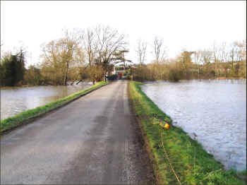
When the water is deep enough, it floods the B4447. At this point, the Causeway is normally opened for vehicles.
-
Flow increases in the Fleet Ditch. When this exceeds the capacity of Maidenhead Ditch and White Brook, Widbrook Common floods.
-
At this stage of a flood, the Thames is likely to have breached its eastern bank, flooding the gardens of the properties on the Buckinghamshire side and leading to the closure of the A4094 to the north of Cookham Bridge.
-
As levels rise on Widbrook Common and the surrounding farmland, the water encroaches on Strand Lane and nearby properties.
Eventually, the body of water held back by the north Maidenhead bund overflows to the east and closes the A4094 at Widbrook Common.
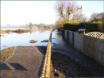
Figure 7-4 Flooding on Cookham Moor, January 2003 (Roger Davies)
-
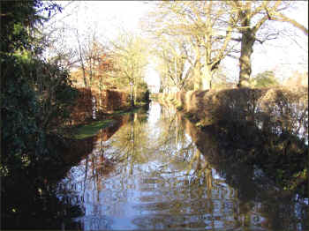
In parallel with the last two events, the Lulle Brooke bursts its banks flooding Odney Common, the Odney Club grounds and closing Mill Lane.
-
In an extreme flood, it is conceivable that water levels above Cookham weir could continue to rise leading to flooding of low lying properties to the east of Sutton Road and south of the Moor.
Ultimately, this would lead to inundation of the bund and extensive flooding of Cookham Village. This scenario is envisaged on the Environment Agency’s flood map (see Figure 7-6).
Figure 7-5 Mill Lane, January 2003 (Roger Davies)
7.5 Continuing Flood Risks
7.5.1 Thames Floods
As seen above, flooding from the Thames remains a significant risk which impacts on Cookham Village and its surroundings including (but not necessarily limited to) parts of Strand Lane, Mill Lane, Cock Marsh and riverside properties in Cookham Dean. In addition, large areas of Bourne End and other riverside areas downstream of Marlow are also at risk.
Lower level impacts include disruption to traffic and public transport while (in an extreme event), there is a risk of significant property damage and injury or loss of life. The report by Water Research Associates for the Upstream Group ( 7.3) identified that there were 17 properties in Cookham at risk of flooding in a severe flood whereas the Environment Agency map suggests an even greater number could be affected in extremis (see Figure 7-6).
At the time of writing (January 2007), it is understood that the Environment Agency is examining options for further flood relief works in the Cookham area. Details were not made available to the Working Group but the scope is understood to include work in the Strand Lane area, a potential extension to the bund across the north side of the Moor and increased capacity at Odney Weir. These works potentially have significant environmental impact and could affect water levels to the north and east of the village. Whilst further protection is welcome, careful scrutiny of their impact and effectiveness will be necessary to ensure that there are no unintended consequences as there were with MWEFAS.
Figure 7-6 Flood Map January 2007 (Environment Agency website, January 2007)
click on map for larger image
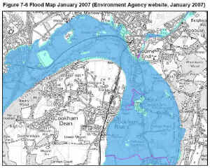
Areas at risk from flooding are shaded in dark blue and those at risk in severe events in light blue. Flood defences are shown as purple lines.
7.5.2 Flash Floods
There has been no repetition of the flash floods in Cookham Dean and Rise since completion of RBWM’s relief measures (this was confirmed by many respondents to our consultation exercise). A theoretical risk of recurrence must remain, particularly with uncertainty over climate change, but at this stage, we have not identified any action required on behalf of the community.
It should, however, be noted that any change in land usage or increase in built or paved areas within the Lower Road / Cookham Dean Bottom catchment area could (individually or cumulatively) increase run-off rates and put the capacity of the relief measures at risk. This should be borne in mind by RBWM when considering planning applications in this area.
7.5.3 Drainage Problems
The questionnaire identified a significant number of concerns about drainage problems across the whole of Cookham. As with flash flooding concerns, we recommend that RBWM investigates and rectifies these issues.
Such a study should also include Thames Water in order to consider associated problems with foul drainage including areas such as the High Street and problems reported in the High Road area where the drains for Worster Road get overloaded and flow into the Alfred Major Playing Field (just by the Primary School playing area).
7.5.4 Global Warming
Climate change is now a recognised factor in environmental matters although its effects remain uncertain. The WRA report for the Upstream Group ( 7.3) compared rises in global surface temperature with reductions in the frequency and severity of Thames floods between 1890 and 2003 and suggested that there may be links – for example, due to milder winters reducing the extent of snow and ice (the third risk factor for flooding). It is impossible to predict how the weather may change in the future and how such changes will affect flooding risk in Cookham.
Nevertheless, it is possible to see that there could be more moderate level Thames floods and a greater risk of flash flooding if either summer temperatures or winter rainfall levels rise.
7.6 Key Findings
-
Flooding from the River Thames is a significant risk for low lying areas of Cookham and has been made worse by the construction of MWEFAS.
-
Although it is almost certainly impossible to prevent flooding of the Thames, further work should be carried out to reduce its risk and impact. This should focus on reducing the effects of mid level floods (such as those in 2003) and minimising the risk of more serious flooding.
-
Until the risk and impact of flooding has been reduced, there should be no relaxation of the special scrutiny placed on planning applications for development in the flood risk areas.
-
No significant new building should be permitted in the ‘at risk’ areas shown on the Environment Agency’s flood map unless it can be shown to be safe for its occupants and to have no impact on the risk to other properties.
-
The village should find ways of working with the Environment Agency to bring forward schemes as soon as possible, however, there must be sufficient scrutiny and challenge to ensure that these are both imaginative, wide ranging and sufficiently well thought through to avoid unintended consequences like those of MWEFAS.
-
In particular, in addition to changes to the bunding and relief measures for the Strand Lane area, consideration should be given to increasing capacity at Cookham’s weirs, protecting against flooding of the Lulle Brooke and reducing flow by diverting the outfall of the River Wye to below Cookham Weir.
-
Traffic Management at times of flood needs to be improved. In particular, the Causeway should be limited to traffic for residential and business access only and suitable signage and traffic management equipment should be stored locally when required. A coordinated plan should be agreed between the parish and borough councils and the police.
-
If the Environment Agency’s proposals do not remove (or significantly reduce) the risk of flooding of the B4447, its level should be raised to maintain access to the village. Alternatively, consideration should be given to closing and removing this road and upgrading the Causeway to form the main route).
-
Until the above item is addressed, there should be regular engineering checks on the Causeway bridge. These should include assessment of the risk of scour from flood waters undermining the foundations. All necessary
-
maintenance work should be scheduled and carried out by the highway authority.
-
Arrangements should be made to ensure that drainage problems are identified and resolved without delay. *A register of items reported to RBWM should be available on the Internet with target and actual response times visible. A local body such as the Parish Council or Cookham Society should monitor performance and hold RBWM to account if this is inadequate.
-
RBWM should carry out a detailed study of the concerns expressed by respondents to the questionnaire about flash flooding and drainage problems across all of Cookham.
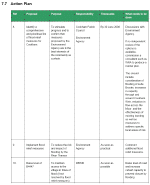
7.7 Action Plan
click on chart to view